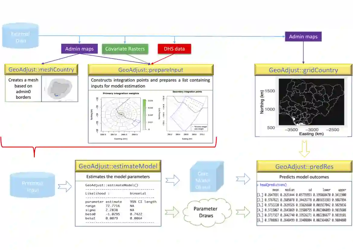
The R-package GeoAdjust https://github.com/umut-altay/GeoAdjust-package implements fast empirical Bayesian geostatistical inference for household survey data from the Demographic and Health Surveys Program (DHS) using Template Model Builder (TMB). DHS household survey data is an important source of data for tracking demographic and health indicators, but positional uncertainty has been intentionally introduced in the GPS coordinates to preserve privacy. GeoAdjust accounts for such positional uncertainty in geostatistical models containing both spatial random effects and raster- and distance-based covariates. The R package supports Gaussian, binomial and Poisson likelihoods with identity link, logit link, and log link functions respectively. The user defines the desired model structure by setting a small number of function arguments, and can easily experiment with different hyperparameters for the priors. GeoAdjust is the first software package that is specifically designed to address positional uncertainty in the GPS coordinates of point referenced household survey data. The package provides inference for model parameters and can predict values at unobserved locations.
翻译:R包GeoAdjust(https://github.com/umut-altay/GeoAdjust-package)利用模板模型构建器(TMB)实现了对人口与健康调查项目(DHS)家庭调查数据的快速经验贝叶斯地统计推断。DHS家庭调查数据是追踪人口与健康指标的重要数据来源,但为保护隐私,其GPS坐标被有意引入了位置不确定性。GeoAdjust在包含空间随机效应以及基于栅格和距离协变量的地统计模型中考虑了这种位置不确定性。该R包分别支持高斯、二项和泊松似然函数,并相应采用恒等链接、对数几率链接和对数链接函数。用户可通过设置少量函数参数定义所需模型结构,并轻松试验先验的不同超参数。GeoAdjust是首个专门处理点参考家庭调查数据GPS坐标位置不确定性的软件包。该包提供模型参数推断功能,并可预测未观测位置的值。