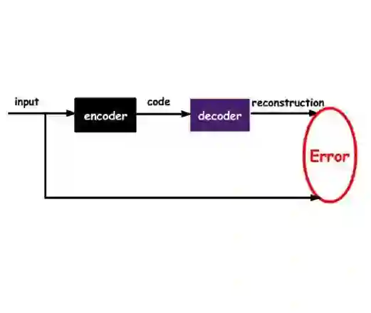
Supervised machine learning methods for geological mapping via remote sensing face limitations due to the scarcity of accurately labelled training data that can be addressed by unsupervised learning, such as dimensionality reduction and clustering. Dimensionality reduction methods have the potential to play a crucial role in improving the accuracy of geological maps. Although conventional dimensionality reduction methods may struggle with nonlinear data, unsupervised deep learning models such as autoencoders can model non-linear relationships. Stacked autoencoders feature multiple interconnected layers to capture hierarchical data representations useful for remote sensing data. This study presents an unsupervised machine learning-based framework for processing remote sensing data using stacked autoencoders for dimensionality reduction and k-means clustering for mapping geological units. We use Landsat 8, ASTER, and Sentinel-2 datasets to evaluate the framework for geological mapping of the Mutawintji region in Western New South Wales, Australia. We also compare stacked autoencoders with principal component analysis and canonical autoencoders. Our results reveal that the framework produces accurate and interpretable geological maps, efficiently discriminating rock units. We find that the accuracy of stacked autoencoders ranges from 86.6 % to 90 %, depending on the remote sensing data type, which is superior to their counterparts. We also find that the generated maps align with prior geological knowledge of the study area while providing novel insights into geological structures.
翻译:利用遥感数据进行地质制图时,监督式机器学习方法因缺乏精确标注的训练数据而面临局限,这一问题可通过无监督学习方法(如降维与聚类)得到解决。降维方法在提升地质图件精度方面具有关键潜力。尽管传统降维方法可能难以处理非线性数据,但自编码器等无监督深度学习模型能够建模非线性关系。堆叠自编码器通过多层互联结构捕获层次化数据表征,这对遥感数据处理尤为有益。本研究提出一种基于无监督机器学习的遥感数据处理框架,该框架采用堆叠自编码器进行降维,并结合k-means聚类实现地质单元制图。我们利用Landsat 8、ASTER和Sentinel-2数据集,在澳大利亚新南威尔士州西部的Mutawintji区域对该框架进行地质制图评估,并比较了堆叠自编码器与主成分分析及典型自编码器的性能。结果表明,该框架能生成精确且可解释的地质图件,有效区分岩性单元。研究发现堆叠自编码器的准确率介于86.6%至90%之间(具体取决于遥感数据类型),其性能优于对比方法。同时,生成的地质图件与研究区已有地质认识高度吻合,并为地质构造解析提供了新的见解。