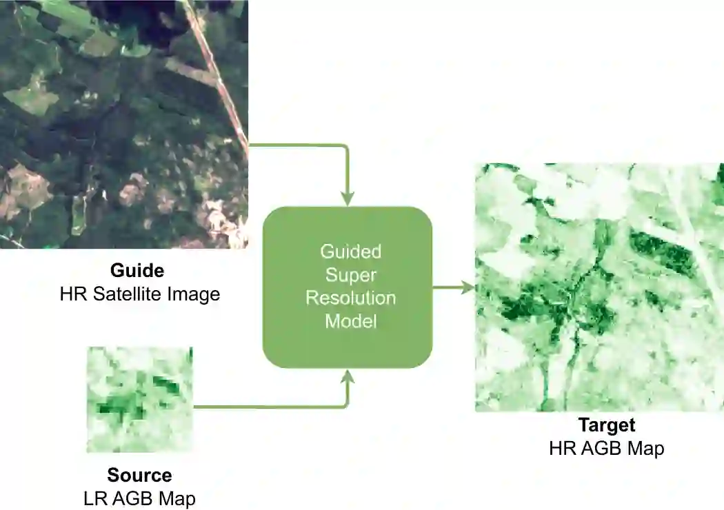
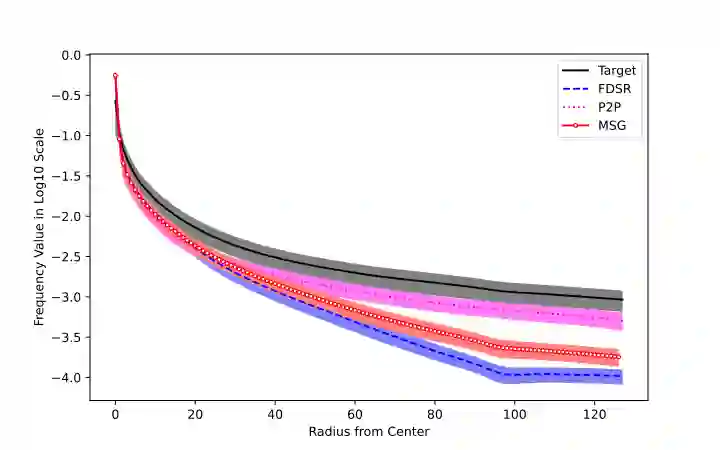
Accurate Above-Ground Biomass (AGB) mapping at both large scale and high spatio-temporal resolution is essential for applications ranging from climate modeling to biodiversity assessment, and sustainable supply chain monitoring. At present, fine-grained AGB mapping relies on costly airborne laser scanning acquisition campaigns usually limited to regional scales. Initiatives such as the ESA CCI map attempt to generate global biomass products from diverse spaceborne sensors but at a coarser resolution. To enable global, high-resolution (HR) mapping, several works propose to regress AGB from HR satellite observations such as ESA Sentinel-1/2 images. We propose a novel way to address HR AGB estimation, by leveraging both HR satellite observations and existing low-resolution (LR) biomass products. We cast this problem as Guided Super-Resolution (GSR), aiming at upsampling LR biomass maps (sources) from $100$ to $10$ m resolution, using auxiliary HR co-registered satellite images (guides). We compare super-resolving AGB maps with and without guidance, against direct regression from satellite images, on the public BioMassters dataset. We observe that Multi-Scale Guidance (MSG) outperforms direct regression both for regression ($-780$ t/ha RMSE) and perception ($+2.0$ dB PSNR) metrics, and better captures high-biomass values, without significant computational overhead. Interestingly, unlike the RGB+Depth setting they were originally designed for, our best-performing AGB GSR approaches are those that most preserve the guide image texture. Our results make a strong case for adopting the GSR framework for accurate HR biomass mapping at scale. Our code and model weights are made publicly available (https://github.com/kaankaramanofficial/GSR4B).
翻译:在大尺度及高时空分辨率下进行准确的地上生物量制图,对于从气候建模、生物多样性评估到可持续供应链监测等应用至关重要。目前,精细尺度的AGB制图依赖于成本高昂的机载激光扫描采集活动,通常仅限于区域尺度。诸如欧空局CCI地图等计划尝试从多种星载传感器生成全球生物量产品,但分辨率较粗。为了实现全球、高分辨率制图,已有若干研究提出从高分辨率卫星观测数据(如欧空局Sentinel-1/2图像)回归估算AGB。我们提出了一种利用高分辨率卫星观测和现有低分辨率生物量产品来解决高分辨率AGB估算问题的新方法。我们将此问题构建为引导式超分辨率重建,旨在利用辅助的高分辨率、已配准的卫星图像作为引导,将低分辨率生物量图从$100$米分辨率上采样至$10$米分辨率。我们在公开的BioMassters数据集上,比较了有引导与无引导的超分辨率AGB图,以及直接从卫星图像进行回归的方法。我们观察到,多尺度引导方法在回归指标和感知指标上均优于直接回归,其均方根误差降低了$780$ t/ha,峰值信噪比提高了$2.0$ dB,并且能更好地捕捉高生物量值,同时没有显著的计算开销。有趣的是,与它们最初设计的RGB+深度场景不同,我们表现最佳的AGB GSR方法是那些最能保留引导图像纹理的方法。我们的结果为采用GSR框架进行大规模、准确的高分辨率生物量制图提供了有力支持。我们的代码和模型权重已公开(https://github.com/kaankaramanofficial/GSR4B)。