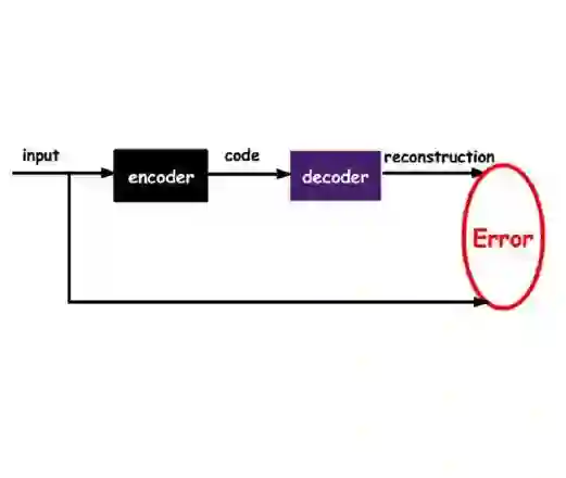
Satellite imagery is employed for large-scale prospectivity mapping due to the high cost and typically limited availability of on-site mineral exploration data. In this work, we present a proof-of-concept framework that leverages generative representations learned from multispectral Sentinel-2 imagery to identify gold-bearing regions from space. An autoencoder foundation model, called Isometric, which is pretrained on the large-scale FalconSpace-S2 v1.0 dataset, produces information-dense spectral-spatial representations that serve as inputs to a lightweight XGBoost classifier. We compare this representation-based approach with a raw spectral input baseline using a dataset of 63 Sentinel-2 images from known gold and non-gold locations. The proposed method improves patch-level accuracy from 0.51 to 0.68 and image-level accuracy from 0.55 to 0.73, demonstrating that generative embeddings capture transferable mineralogical patterns even with limited labeled data. These results highlight the potential of foundation-model representations to make mineral exploration more efficient, scalable, and globally applicable.
翻译:由于实地矿物勘探数据成本高昂且通常有限,卫星影像被用于大规模远景测绘。本研究提出一个概念验证框架,该框架利用从多光谱Sentinel-2影像中学习到的生成式表征,从太空识别含金区域。一个名为Isometric的自编码器基础模型,在大规模FalconSpace-S2 v1.0数据集上进行预训练,可生成信息密集的光谱-空间表征,作为轻量级XGBoost分类器的输入。我们使用来自已知金矿和非金矿位置的63幅Sentinel-2影像数据集,将这种基于表征的方法与原始光谱输入基线进行比较。所提方法将像元级准确率从0.51提升至0.68,影像级准确率从0.55提升至0.73,证明即使标记数据有限,生成式嵌入也能捕获可迁移的矿物学模式。这些结果凸显了基础模型表征在提高矿物勘探效率、可扩展性和全球适用性方面的潜力。