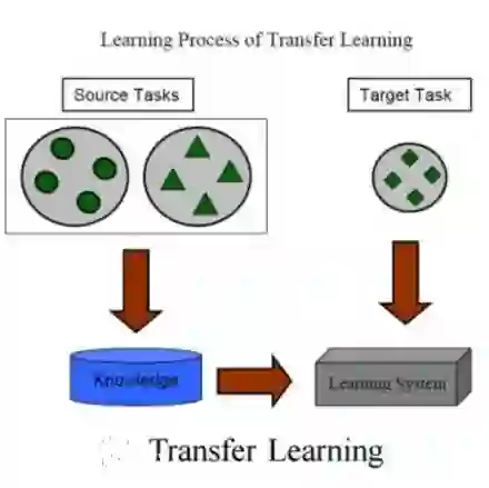
Convolutional Neural Networks (CNNs) have proven instrumental across various computer science domains, enabling advancements in object detection, classification, and anomaly detection. This paper explores the application of CNNs to analyze geospatial data specifically for identifying wildfire-affected areas. Leveraging transfer learning techniques, we fine-tuned CNN hyperparameters and integrated the Canadian Fire Weather Index (FWI) to assess moisture conditions. The study establishes a methodology for computing wildfire risk levels on a scale of 0 to 5, dynamically linked to weather patterns. Notably, through the integration of transfer learning, the CNN model achieved an impressive accuracy of 95\% in identifying burnt areas. This research sheds light on the inner workings of CNNs and their practical, real-time utility in predicting and mitigating wildfires. By combining transfer learning and CNNs, this study contributes a robust approach to assess burnt areas, facilitating timely interventions and preventative measures against conflagrations.
翻译:卷积神经网络(CNNs)已证明在多个计算机科学领域具有关键作用,推动了目标检测、分类和异常检测等方向的进步。本文探索将CNN应用于地理空间数据分析,具体聚焦于识别受野火影响的区域。通过利用迁移学习技术,我们优化了CNN超参数并整合了加拿大火险天气指数(FWI)以评估湿度状况。研究建立了一种动态关联天气模式的野火风险等级计算方法,将风险值设定为0至5级。值得注意的是,通过迁移学习的集成,CNN模型在识别过火区域方面达到了95%的卓越准确率。本研究揭示了CNN的内部运作机制及其在野火预测与缓解中的实时实用价值。通过结合迁移学习与CNN,该研究为过火区域评估提供了稳健的方法论,有助于及时采取干预措施和预防性对策以应对火灾。